USUS UKUKIndiaIndia

Every Question Helps You Learn

Join Us
Streak
Leading Streak Today
Your Streak Today
Streak
Leading Streak Today
Your Streak Today
Flooding and Management
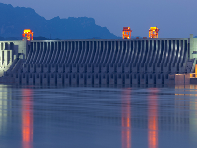
The Three Gorges Dam in China has proven to be a positive in terms of flood risk reduction.

Flooding and Management

This Geography quiz is called 'Flooding and Management' and it has been written by teachers to help you if you are studying the subject at high school. Playing educational quizzes is a user-friendly way to learn if you are in the 9th or 10th grade - aged 14 to 16.

It costs only $12.50 per month to play this quiz and over 3,500 others that help you with your school work. You can subscribe on the page at Join Us

As a part of their study of rivers in high school, Geography students will look at flooding. This is the second of two quizzes on that topic and it looks at both the risk of floods and their management.

1 .
For hundreds of years sheep farmers have been managing the uplands of Britain. How does their management increase the risk of flooding?
Sheep eat the grass, destroying the plants and reducing the water uptake
There is an increased drainage of marshland to make it suitable for grazing
The machinery needed to take care of the sheep destroys the soil structure
Sheep increase erosion as they move across the landscape
The main increase to flooding caused by sheep farming comes from draining the marshlands to make it more suitable for grazing. The farmers are forced to add more field drainage to keep the fields from being waterlogged and harming the sheep. This water enters rivers and so increases the risk of floods
2 .
Which of the following is not an example of flood proofing for buildings?
Flood barriers for doorways
Raised electrical sockets
Increased ventilation via ground level air bricks
Valves on sewage and water systems to prevent backflow
Flood proofing can be divided into dry proofing (i.e. stopping the water getting in) and wet proofing (i.e. reducing the damage done when the water gets in)
3 .
The Three Gorges Dam in China has proven to be a positive in terms of flood risk reduction, but which of the following is not one of the negatives of the construction of large-scale dams such as this one?
Some species of fish and other aquatic animals may be driven to extinction
Millions of people have to be displaced from their homes to make way for the reservoir
The silt and pollution carried by rivers is deposited behind the dam, gradually filling up the reservoir
The discharge rates down river will be altered
One advantage of a dam is that discharge rates can be altered and controlled. Holding back water during periods of high flow and releasing them during periods of lower water levels, can reduce flooding and maintain a regular level in the river
4 .
In 2014 residents living on the Somerset Levels accused the government of not preventing the flooding by failing to dredge the rivers and drainage ditches that criss-cross the land. How might this lack of dredging have contributed to the floods?
The shallower rivers and drainage had a reduced capacity. Had they been deeper the drainage system may have been able to drain the water out of the Somerset Levels
The main river channel had silted up entirely blocking the water from escaping. This caused the water to back up and lead to the flooding
Because of the silt in the channel and the amount carried by the river itself there was more volume of discharge, leading to the water overflowing the banks and flooding the area
The silting of the channel allowed the river to pick up greater velocity, causing greater damage when it escaped its banks
The Levels are at a very low level meaning it is naturally flooded for part of the year. Drainage ditches have been cut, recut and extended since the prehistoric period to drain the water away. Soft engineering methods, as well as a lack of funding, mean that the channels have been allowed to silt up preventing the water draining
5 .
One way of reducing the flood risk is to recreate peat bogs in the upland areas of drainage basins. How do these peat bogs help reduce the risk of flooding?
Peat bogs allow the water to pass an area quicker
Peat bogs direct the water into ground water supplies rather than allowing it to pass across the surface
Peat bogs act like a sponge, retaining water and releasing it slowly
Peat bogs increase evaporation because of the large number of trees found in these ecosystems
Peat bogs can reduce discharge levels by up to 25% by drawing the water in and gradually releasing it as water levels fall
6 .
What is a washland?
An area that is deliberately flooded during times of heavy river flow to avoid flooding elsewhere
A area that is dredged out to allow faster flow to avoid a flood risk
An area near a river that is protected to prevent flooding as this can risk the bank stability
An area of the riverbed, normally downstream of a straightened section, that is scoured out by high velocity flow
Leaving areas to flood naturally along most of the length of the river can allow some areas where buildings have already been built at the rivers edge to be protected. This is an example of soft engineering
7 .
In the 18th and 19th Centuries people began straightening sections of the Mississippi to aid navigation. How does straightening channels impact on the flood risk?
The water builds up as it enters the straightened cut, increasing the risk upriver and decreasing the risk down river of the cut
The water passes through the straightened sections faster, decreasing the risk upriver, but increasing the risk down-river of the cut section
The water passes into the cut faster, leading to flooding either side of the cut
Straightening the cut has no measurable effect on the flood risk, although it makes it much safer to navigate
Other rivers, such as the River Mersey that flows through Manchester and Liverpool, have been so heavily straightened that little of the original river remains. This means the water moves down river very rapidly and this dramatically increases flooding at the few sections that still meander
8 .
Beavers are being reintroduced to the British countryside. How are they helping to manage flood risks?
Beaver tunnels undermine banks and allow them to collapse, creating a wider and shallower river that is hard for the water to escape from
Beavers destroy trees which stabilize river banks and so reduce flooding
Beavers encourage tourism that brings more money into the local economy that can be spent on flood defenses
Beavers create dams that trap water upstream, allowing it to flood undeveloped higher land
Beavers make huge dams that act as natural pools and marshes, holding back water in times of flood and releasing it gradually as water levels fall
9 .
Which of the following are systems that might be in place in Flood Plain Zoning?
Grazing areas zoned on higher ground
Roads and parking lots situated closer to the river than factories
Industry located directly on the river banks
Critical infrastructure (e.g. hospitals) closer to the river than residential properties
In general, farming and playing fields are located closest to the river, with parking lots coming next, followed by industry, then residential properties and finally critical infrastructure
10 .
Which of the following is an example of hard engineering to help prevent flood damage?
Planting trees in upland areas
Allowing a river to naturally flood into dedicated areas
Straightening a river channel
A planning restriction placed on an area of high flood risk
Anything that requires building something or physically altering the river is commonly considered hard engineering
Author:  Ruth M

© Copyright 2016-2025 - Education Quizzes
Work Innovate Ltd - Design | Development | Marketing