Ask the AI Tutor
Need help with Earthquakes and Volcanoes 02? Ask our AI Tutor!
AI Tutor - Lucy
Connecting with Tutor...
Please wait while we establish connection

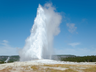
This photo shows a geyser which is heated underground water that rises to the surface under extreme pressure.
Earthquakes and Volcanoes 02
Dormant and extinct volcanoes still shape our world. This KS3 Geography quiz helps you explore eruptions, hazards and how people live with active volcanic landscapes.
1 .
A volcano not expected to erupt again is called what?
Dead
Extinct
Idle
Obsolete
All the volcanoes in the British Isles are extinct. Phew!!
2 .
An earthquake can be measured on what scale?
Reuter
Richter
Richthofen
Rickman
At the time of writing this quiz, the world's strongest recorded earthquake was magnitude 9.5. It occured in the Pacific Ocean near Chile in 1960
3 .
Heated underground water rising to the surface under huge pressure is a...?
Geezer
Geyser
Giza
Gyeeser
Probably the best known geyser is 'Old Faithful' which is in Yellowstone National Park in the USA
4 .
Earthquakes are most likely to happen where?
In the centre of plates
Near plate edges
Under the highest mountains
Where major rivers enter oceans
The edges of plates are very unstable areas - rocks don't move past each other very easily!
5 .
What form does the mantle take?
Gas
Ice
Semi-liquid
Solid rock
Currents in the mantle are thought to be what move the crustal plates
6 .
How can you tell that South America and Africa were once joined?
America and Africa both begin and end with 'a'
By the shape of their coastlines
The native people look alike
They both have major deserts
They split apart as the earth's plates moved, forming the Atlantic Ocean
7 .
Mauna Loa is a volcano in which American state?
Alaska
Hawaii
Montana
New Mexico
Hawaii has a national park called 'Volcanoes'
8 .
Large rocks thrown from a volcano have what name?
Bombs
Bricks
Lava lumps
Missiles
They can be thrown hundreds of feet in the air and are very dangerous to people and buildings near to an eruption
9 .
Which layer is immediately below the earth's crust?
Core
Horizon
Mantle
Margin
The mantle is a much thicker layer than the crust
10 .
Which ocean has a ring of earthquakes and volcanoes around its edge?
Arctic
Atlantic
Indian
Pacific
Known as the 'Pacific Ring of Fire'
**Unlimited Quizzes Await You! 🚀**
Hey there, quiz champ! 🌟 You've already tackled today's free questions.
Ready for more?
Ready for more?
🔓 Unlock UNLIMITED Quizzes and challenge yourself every day. But that's
not all...
not all...
🔥 As a Subscriber you can join our thrilling "Daily Streak" against other
quizzers. Try to win a coveted spot on our Hall of Fame Page.
quizzers. Try to win a coveted spot on our Hall of Fame Page.
Don't miss out! Join us now and keep the fun rolling. 🎉
**Unlimited Quizzes Await You! 🚀**
Hey there, quiz champ! 🌟 You've already tackled today's free questions. Ready for more?
🔓 Unlock UNLIMITED Quizzes and challenge yourself every day. But that's not all...
🔥 As a Subscriber you can join our thrilling "Daily Streak" against other quizzers. Try to win a coveted spot on our Hall of Fame Page.
Don't miss out! Join us now and keep the fun rolling. 🎉


