Ask the AI Tutor
Need help with OS Maps: Scale, Distance and Direction? Ask our AI Tutor!
AI Tutor - Lucy
Connecting with Tutor...
Please wait while we establish connection
See if you can get full marks in this enjoyable quiz.
OS Maps: Scale, Distance and Direction
OS maps use scale, symbols, and compass directions to represent real places. Learn how to measure distances accurately and describe directions clearly for your GCSE Geography exams.
To see a larger image, click on the picture.
1 .
A group of students on an exchage trip to France were given a town map. They needed to get to the station (marked B on the plan) as quickly as possible. They were at point A on the map. In which direction did they need to walk?
South east
South west
North west
North east
If north is not marked on a map, in most cases, you can assume that it is at the top
2 .
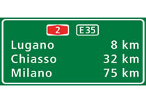
This is a picture of an actual road sign in use in Switzerland. If you were using a road map with a scale of 1:100,000, how many cm from the location of the sign would Lugano be?
8 cm
32 cm
75 cm
100 cm
The scale tells you how many cm in the landscape are represented by one cm on the map, on this scale of map, 1 cm represents 1 km
3 .
The photograph shows a trig pillar. What were they used for?
They were used by the Ordnance Survey for accurate surveying to help them to produce maps
They were built during the second world war for defence purposes
They were used as emergency stations to help lost hikers
They were used as rain guages
They are also called trig points and no longer in use. They were built in 1936 to help the Ordnance Survey produce very accurate maps of Britain using a process called triangulation. It took 26 years to complete the work! The OS now use GPS to add new map features more accurately and in just a few seconds
4 .
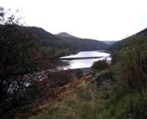
Using an OS map of the Peak District, the source of the river Ashop is in grid square 0691. It flows a few kilometres into Ladybower reservoir in grid square 1687. In which general direction does it flow?
Slightly west of north
Due south
Slightly south of east
Due east
You should know that the first pair of numbers in a four figure grid reference are the 'eastings'. These increase as you move further east on an OS map, so you can eliminate the first two alternatives as the source is further east than where it reaches the reservoir. The second pair of numbers is the 'northings' and they decrease towards the south so you can eliminate the fourth option. The change in eastings is 10 squares but the decrease in northings is only 4 squares which confirms the third option as being correct
5 .
6 .
The photo shows a picture of Leeds, a large city in the UK. On an OS map, scale 1:50,000, a student drew a line, direction 90° east for 2 cm then continued it for 2 cm, in direction 180° followed by 2 cm in direction 270°. In the landscape, how far away from the starting point is the end point?
0.5 km
1.0 km
2.0 km
0.0 km
On the 1:50,000 scale map, 2 cm represent 1 km on the ground. The first direction was therefore 1 km east, the second was 1 km south and the third was 1 km west, meaning that 3 sides of a square were completed and the final point is 1 km due south of the starting point
7 .
The scale of this plan is 1:5,000. Each grid square measures 2 cm x 2 cm. What area is represented by one grid square?
0.01 square kilometres
1 hectare
10,000 square metres
All of the above
1 cm on the map represents 50 m in the landscape. A grid square of 2 cm therefore has sides of 100 m in length. 100 m x 100 m = 10,000 m2. For the exam, you need to know the relationship between the different units of area - sometimes geography can seem more like maths!
8 .
9 .
Montreal is a city in Canada. Its coordinates are 45.5° N, 73.6° W. Which of the following European cities would be almost exactly due east of Montreal?
London (51.5° N, 0.13° W)
Berlin (52.5° N, 13.4° E)
Oslo (59.9° N, 10.8° E)
Lyon (45.8° N, 4.8° E)
The climate of the two cities is very different even though they are at similar distances from the North Pole
10 .
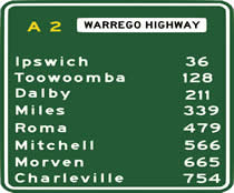
If you were drawing a map of the Warrego Highway, how many cm would you need between Ipswich and Toowoomba?
128 at a scale of 1:25,000
184 at a scale of 1:50,000
92 at a scale of 1:75,000
All of the above are correct
The two towns are 92 km apart on the highway. On a scale of 1:25,000 1 km is represented by 4 cm on the map and the number does not correctly take into account the distance between the two towns, so this answer must be wrong. That immediately makes the fourth option wrong too. A scale of 1:50,000 represents 1 km using 2 cm which is 184 cm therefore the second option is correct
**Unlimited Quizzes Await You! 🚀**
Hey there, quiz champ! 🌟 You've already tackled today's free questions.
Ready for more?
Ready for more?
🔓 Unlock UNLIMITED Quizzes and challenge yourself every day. But that's
not all...
not all...
🔥 As a Subscriber you can join our thrilling "Daily Streak" against other
quizzers. Try to win a coveted spot on our Hall of Fame Page.
quizzers. Try to win a coveted spot on our Hall of Fame Page.
Don't miss out! Join us now and keep the fun rolling. 🎉
**Unlimited Quizzes Await You! 🚀**
Hey there, quiz champ! 🌟 You've already tackled today's free questions. Ready for more?
🔓 Unlock UNLIMITED Quizzes and challenge yourself every day. But that's not all...
🔥 As a Subscriber you can join our thrilling "Daily Streak" against other quizzers. Try to win a coveted spot on our Hall of Fame Page.
Don't miss out! Join us now and keep the fun rolling. 🎉


